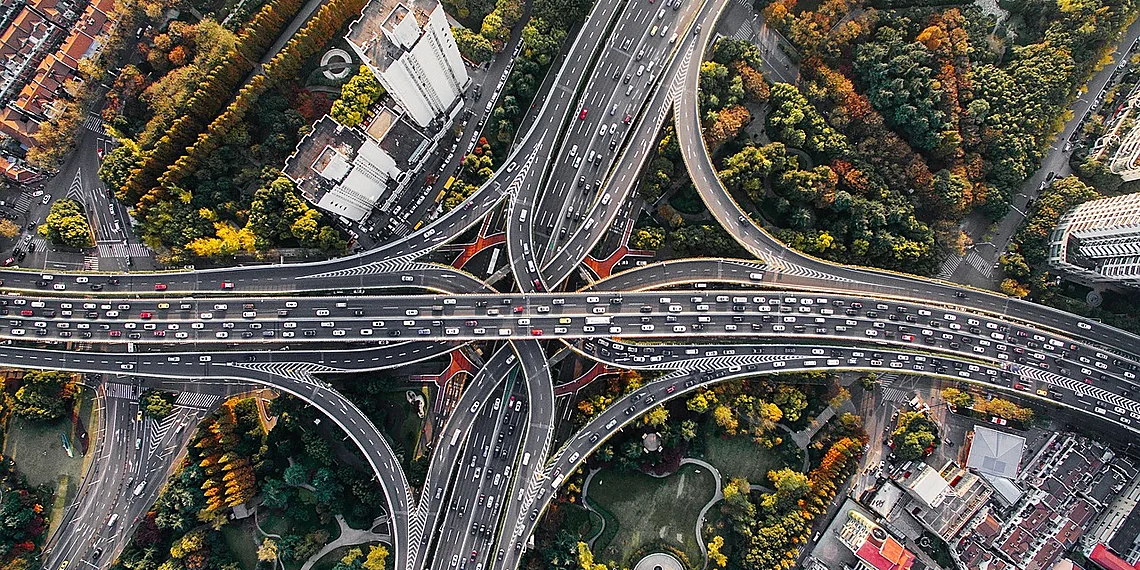


Cities are vibrant hubs of innovation and opportunity, but they also face a persistent challenge: crippling traffic congestion. The daily commute has become synonymous with frustration for millions, costing valuable time and impacting productivity across industries. Beyond the personal inconvenience, this constant gridlock carries a significant environmental price tag, contributing to air pollution and negatively affecting public health.
The sheer volume of vehicles navigating urban landscapes generates substantial Urban Traffic Emissions, a complex mix of pollutants that exacerbate respiratory problems and contribute to climate change. Traditional methods for assessing and predicting these emissions often fall short, relying on simplified models that don’t fully account for real-world variability in traffic patterns and vehicle behavior.
Fortunately, advancements in artificial intelligence are offering promising solutions. Emerging methodologies like embedded Multi-Functional Deep learning (eMFDs) provide a powerful new approach to modeling complex systems; they integrate multiple functionalities into a single model, allowing for more nuanced predictions. These models have the potential to revolutionize how we understand and mitigate the impact of urban transportation.
Imagine being able to accurately forecast emission levels based on dynamic factors like weather conditions, time of day, and even individual driver behavior – that’s the power eMFDs offer. They represent a crucial step towards creating smarter, more sustainable cities for everyone.
The Challenge of Urban Emissions
Urban traffic emissions represent a significant and multifaceted challenge for cities worldwide. Beyond the immediate frustration of gridlock, congestion carries substantial economic, environmental, and social costs. Economically, lost productivity due to delays amounts to billions annually; environmentally, it directly contributes to poor air quality and exacerbates climate change through greenhouse gas emissions; and socially, it impacts public health and disproportionately affects vulnerable populations living near major roadways. For example, the INRIX Global Traffic Congestion Cost Study estimated that congestion cost drivers $912 billion globally in 2023 alone – a staggering figure highlighting the urgency of finding solutions.
Historically, efforts to model and mitigate urban traffic emissions have relied on macroscopic emission fundamental diagram (eMFD) models. These diagrams attempt to capture the relationship between aggregated traffic variables and resulting emissions at a network level. While offering potential for real-time monitoring and optimal travel demand allocation – theoretically allowing cities to reduce congestion and associated pollution – eMFDs face a critical limitation: they depend on extensive historical data that is often sparse or unavailable in many urban environments. This lack of empirical data severely restricts their accuracy and applicability.
Traditional approaches also struggle with the inherent complexity of urban traffic patterns. Factors like road geometry, vehicle mix (cars, trucks, buses), weather conditions, driver behavior, and even time of day all intricately influence emissions. Capturing these nuances with simplified models is difficult, often leading to inaccurate predictions and ineffective mitigation strategies. Furthermore, many existing methods fail to account for the granular, micro-level variations in emission profiles that can occur within a single city block.
The need for more accurate and adaptable models is clear. Current research, as highlighted by recent work leveraging large-scale probe vehicle data and machine learning techniques (arXiv:2511.08722v1), offers promising avenues to overcome these limitations. By moving beyond traditional reliance on sparse historical data, we can potentially unlock a deeper understanding of urban traffic emissions and develop targeted interventions to improve air quality and reduce the environmental impact of our cities.
Congestion’s Hidden Costs

Traffic congestion isn’t just frustrating; it carries a substantial economic burden. The INRIX 2023 Global Traffic Scorecard estimates that drivers worldwide lost 9,186 million hours to congestion in 2023 alone, costing $475 billion in wasted time and fuel. In the United States, this translates to an average cost of $1,900 per driver annually due to congestion-related delays and increased fuel consumption. These costs encompass not only direct expenses like gasoline but also lost productivity for individuals and businesses.
Beyond economics, urban traffic emissions pose significant environmental and social risks. Congested roadways contribute heavily to air pollution, with vehicles being a primary source of pollutants like nitrogen oxides (NOx), particulate matter (PM2.5), and carbon monoxide (CO). These pollutants directly impact public health, exacerbating respiratory illnesses and cardiovascular problems, particularly in vulnerable populations living near major roads. Furthermore, traffic congestion is a significant contributor to greenhouse gas emissions; transportation accounts for roughly 27% of total U.S. GHG emissions, with idling vehicles during peak hours dramatically increasing this figure.
Traditional methods of modeling urban emissions often face limitations due to data scarcity and the complexity of factors influencing emission rates. Empirical models based on macroscopic fundamental diagrams (eMFDs) – which attempt to relate traffic flow to emissions at a network level – are valuable but historically difficult to develop with sufficient accuracy and breadth. The need for granular, real-time data across entire urban networks has hindered progress, highlighting the potential of leveraging new sources like probe vehicle data and machine learning techniques for improved emission prediction and mitigation strategies.
Understanding eMFDs: A New Approach
Traditional approaches to modeling urban traffic emissions often focus on vehicle-specific factors or localized areas, providing a fragmented and incomplete picture of the problem. Enter macroscopic emission fundamental diagrams, or eMFDs – a relatively new concept offering a more holistic solution. Think of an eMFD as a map showing how overall emissions change based on the flow of traffic across an entire network, like a city’s road system. Instead of analyzing individual cars, it looks at aggregated variables such as average speed and density to understand the relationship between traffic patterns and total emissions.
What makes eMFDs so valuable? Primarily, they provide a network-level view, allowing for a much broader understanding of emission sources than traditional models. This enables real-time monitoring of regional emissions – imagine being able to instantly see how congestion hotspots are impacting air quality across the city. Furthermore, this data empowers more sophisticated traffic management strategies. By analyzing eMFDs, transportation planners can identify opportunities to optimize travel demand and allocate vehicles to less congested routes, ultimately reducing overall urban congestion and associated emissions.
The power of eMFDs lies in their ability to connect macroscopic traffic flow with emission rates, providing a framework for proactive intervention. While the concept holds immense promise, creating accurate eMFD models has historically been challenging due to limitations in available data. This new research tackles that challenge head-on by leveraging large-scale and granular traffic and emissions data gathered from probe vehicles – essentially, GPS information from cars on the road – combined with machine learning techniques to predict network-wide emission rates based on traffic conditions. This marks a significant step forward in refining our ability to understand and mitigate urban traffic emissions.
What are eMFDs, and Why Do They Matter?

Traditional models for estimating urban traffic emissions often rely on vehicle-level data or simplified assumptions about network behavior. A new approach, utilizing what’s called an Emission Fundamental Diagram (eMFD), offers a significant upgrade. Simply put, an eMFD describes the relationship between overall emission levels and aggregated traffic variables – things like average speed, density of vehicles, and total flow – across an entire transportation network. Instead of focusing on individual cars, it looks at the ‘big picture’ of how emissions change as traffic patterns shift.
The key advantage of eMFDs lies in their network-level perspective. This allows for a more holistic understanding of emission sources and provides insights that vehicle-specific models often miss. Furthermore, because eMFDs are based on continuous data streams, they have the potential to enable real-time monitoring of emissions across an entire city or region. Imagine being able to instantly see which areas are experiencing high pollution levels and adjust traffic flow accordingly.
This capability opens doors for optimized traffic management strategies. By understanding how different traffic conditions impact overall emissions – as described by the eMFD – transportation planners can proactively manage demand, reroute vehicles, and implement policies that reduce congestion and minimize environmental impact. The research highlighted in this article utilizes machine learning to predict these network-wide emission rates, paving the way for more effective and data-driven urban traffic management.
Machine Learning Steps In
Traditional methods for creating emission fundamental diagrams (eMFDs) – tools crucial for understanding and mitigating urban traffic emissions – have long been hampered by a significant limitation: sparse data. Empirical eMFD models rely on historical measurements, which are often insufficient to accurately represent the complex interplay of factors influencing emissions across an entire city network. This scarcity restricts their ability to provide real-time monitoring and effective strategies for demand management aimed at reducing congestion and pollution. However, recent research detailed in arXiv:2511.08722v1 is demonstrating a promising shift towards more accurate and dynamic eMFD generation through the application of machine learning.
The breakthrough lies in leveraging the wealth of data now available from probe vehicles – GPS-equipped cars, trucks, and other vehicles that continuously report their location and speed. Unlike traditional traffic counters or limited sensor networks, probe vehicle data offers unprecedented granularity and scale; providing insights into individual vehicle movements across vast areas and over extended periods. This allows researchers to build a much more detailed picture of how traffic flow directly impacts emissions. The study utilizes this rich dataset to train machine learning models capable of predicting network-wide emission rates based on real-time traffic conditions, effectively bypassing the limitations of historical data reliance.
While the potential is immense, working with such large and granular datasets presents its own set of challenges. Data quality is paramount; ensuring accuracy and consistency across millions of vehicle reports requires sophisticated cleaning and validation techniques. Furthermore, the sheer volume of data demands significant computational resources for both training and deploying these machine learning models. The complexity of urban traffic patterns – influenced by everything from weather to time of day – also necessitates advanced algorithms capable of capturing these intricate relationships and generalizing effectively to unseen conditions.
Ultimately, this innovative approach represents a significant step forward in our ability to understand and manage urban traffic emissions. By harnessing the power of machine learning and probe vehicle data, researchers are creating more accurate and responsive eMFD models that can inform real-time interventions, optimize travel demand, and contribute towards cleaner, healthier cities.
Leveraging Probe Vehicle Data
Probe vehicle data, also known as GPS traces or floating car data, refers to location information collected from vehicles equipped with GPS devices. This includes everything from smartphones in navigation apps to dedicated tracking systems within commercial fleets. Unlike traditional traffic sensors like loop detectors or roadside cameras which provide limited point measurements, probe vehicle data offers a much more granular view of traffic flow across an entire urban area – essentially capturing the movement of a significant portion of vehicles in real-time.
The primary advantage of using probe vehicle data lies in its scale and resolution. The sheer volume of available data points allows for a far more detailed understanding of traffic patterns than previously possible. This high granularity enables researchers to pinpoint congestion hotspots, identify variations in speed across different road segments, and track changes in travel times with unprecedented accuracy. By analyzing this massive dataset, the new approach aims to overcome the historical scarcity of data that has limited the development of accurate emission fundamental diagram (eMFD) models.
However, working with probe vehicle data presents significant challenges. The datasets are incredibly large, requiring substantial computational resources for storage and processing. Data quality is another concern; GPS signals can be unreliable due to urban canyons or weather conditions, and privacy considerations necessitate careful anonymization techniques. Furthermore, integrating this diverse data stream – which may come from various sources with differing formats and accuracy levels – requires sophisticated data cleaning and harmonization processes.
Future Implications & Actionable Insights
The implications of this research extend far beyond simply understanding the current state of urban traffic emissions. The ability to accurately predict network-wide emission rates using machine learning applied to granular traffic data unlocks a new era of proactive, rather than reactive, urban planning and management. Imagine city planners having real-time visibility into how changes in road closures, special events, or even weather patterns will impact emissions across the entire metropolitan area – this research provides a foundation for that capability.
One particularly promising avenue lies in data-driven traffic management strategies. Transportation authorities can utilize these empirically derived emission fundamental diagram (eMFD) models to dynamically adjust signal timings and optimize route guidance systems, not just for speed, but specifically to minimize emissions. This could involve creating personalized routing suggestions – guiding drivers along paths that reduce their environmental footprint – or implementing incentive programs rewarding users who choose lower-emission routes during peak congestion periods. The key is shifting from a system focused solely on throughput to one prioritizing both efficiency and sustainability.
Furthermore, the predictive power of these models allows for more robust long-term urban planning decisions. Future infrastructure projects, such as new roads or public transportation lines, can be evaluated not only based on their impact on congestion but also on their projected effect on emissions. This holistic approach is crucial for building truly sustainable and livable cities. The ability to simulate the effects of different policies before implementation – testing various traffic flow scenarios and observing the resulting emission profiles – significantly reduces risk and maximizes positive outcomes.
Looking ahead, continued refinement of these machine learning models using even more granular data will be essential. Incorporating factors like vehicle type (electric vs. gasoline) and driver behavior could further enhance accuracy and provide a more nuanced understanding of urban traffic emissions. This research represents a significant step towards creating smarter, cleaner, and healthier cities for all.
Data-Driven Traffic Management
The emergence of data-driven emission fundamental diagrams (eMFDs) presents a transformative opportunity for transportation authorities seeking to optimize urban traffic flow and reduce emissions. Traditionally, traffic management has relied on reactive measures; eMFDs, however, offer a proactive approach by providing real-time visibility into the relationship between traffic variables – such as speed, density, and volume – and resulting emission levels across entire networks. This granular understanding allows for more precise interventions aimed at minimizing congestion hotspots and reducing overall pollution output.
Transportation agencies can leverage these eMFDs to implement intelligent routing strategies. By analyzing predicted emission rates based on current and projected traffic conditions, systems can dynamically suggest alternative routes to drivers, diverting them away from congested areas with high emissions. Furthermore, incentive programs could be designed to reward drivers who choose lower-emission routes or utilize public transportation during peak hours, effectively shifting travel demand towards more sustainable options. This personalized routing, coupled with incentives, contributes directly to a reduction in urban traffic emissions.
Looking ahead, the integration of eMFD models into existing traffic management platforms promises significant advancements. Predictive capabilities allow for anticipatory adjustments to signal timing and ramp metering, preventing congestion before it arises. Continuous refinement of these models through ongoing data collection will further enhance their accuracy and responsiveness, ultimately contributing to more efficient transportation networks and healthier urban environments.
The convergence of artificial intelligence and environmental monitoring offers a genuinely transformative opportunity for our cities, as we’ve seen throughout this exploration. Our analysis clearly demonstrates that AI models possess remarkable potential to accurately predict and ultimately mitigate the pervasive problem of urban traffic emissions. These sophisticated tools can move us beyond reactive measures towards proactive strategies, optimizing routes, predicting congestion hotspots, and informing policy decisions with unprecedented precision. The ability to forecast emission levels allows for targeted interventions – from adjusting signal timings to encouraging alternative transportation methods – creating a ripple effect of positive environmental impact. Addressing concerns around data privacy and model transparency remains vital as we scale these solutions, but the initial results are undeniably promising. Reducing urban traffic emissions requires innovative approaches, and AI provides a powerful new weapon in this fight for cleaner air and healthier communities. Let’s embrace this technology responsibly to build more sustainable urban environments for generations to come. We encourage you to delve deeper into the world of sustainable transportation solutions – explore electric vehicle incentives, investigate public transit improvements, and discover how data-driven traffic management is reshaping our cities. Support organizations working towards these goals; your engagement can directly contribute to a brighter, cleaner future.
Your continued learning and advocacy are crucial in driving this change forward.
Continue reading on ByteTrending:
Discover more tech insights on ByteTrending ByteTrending.
Discover more from ByteTrending
Subscribe to get the latest posts sent to your email.